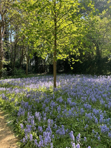
This guide showcases over 50 walking routes across Northamptonshire, grouped by area. Each entry lists the length, location, a unique description of the route and a link to find out more. Enjoy exploring the county’s diverse landscapes, from tranquil reservoirs and ancient forests to historic villages and riverside paths.
Northampton & Surroundings
Brixworth & Pitsford Water Circuit
Length: 6 miles
Location: Brixworth & Pitsford, north of Northampton
This circular trail starts from Brixworth Country Park and follows well‑made paths around Pitsford Water, one of Northamptonshire’s largest reservoirs. Walkers pass sailing clubs, reedbeds and woodland fringes with far‑reaching views across open countryside. Picnic spots and bird hides make this a relaxed outing suitable for families.
Northampton Heritage Trail
Length: 2 miles
Location: Northampton town centre
A self‑guided heritage walk through Northampton’s historic core. Starting at the Guildhall, the route winds past All Saints Church, the Victorian market square and the 900‑year‑old church of the Holy Sepulchre. Interpretive plaques tell stories of the shoe industry, the Great Fire of 1675 and civic buildings. Ideal for those seeking culture within a compact route.
Upton Country Park & Mill Loop
Length: 4 miles
Location: Upton & Kislingbury
Beginning at Upton Country Park, this loop follows the River Nene towards Kislingbury Mill. The riverside path passes meadows alive with dragonflies and leads to the mill’s old weir. From here the trail returns via quiet village lanes and farmland, offering views back to Northampton’s skyline.
Harlestone Firs Woodland Walk
Length: 3 miles
Location: Harlestone
A shady circuit through ancient woodland owned by the Althorp Estate. Footpaths weave among towering conifers and native broadleaf trees, revealing pockets of heathland and the occasional deer. Waymarked trails keep you on track, and parking is available at the entrance on Harlestone Road.
Brampton Valley Way
Length: Up to 14 miles (choose shorter sections)
Location: Northampton to Market Harborough
Following a former railway line, this flat, traffic‑free trail stretches north from Northampton through open countryside. Walkers can start at any of several car parks, passing old railway bridges, two lit tunnels and views towards the Brampton hills. It’s shared with cyclists and forms part of National Cycle Route 6.
Abington Park & Nene Riverside
Length: 3.5 miles
Location: Abington, Northampton
This urban walk links the tree‑lined avenues of Abington Park with the tranquil banks of the River Nene. Stroll past lakes, rose gardens and the ruins of a 16th‑century manor before crossing into the riverside meadows. A circular return along the Nene Way brings you back to the park.
Delapré Abbey & Hardingstone Fields
Length: 4 miles
Location: Delapré Abbey & Hardingstone
Explore the grounds of Delapré Abbey and the adjoining countryside. The route circles the abbey parkland, crosses the ancient London Road to Hardingstone village and climbs to the Queen Eleanor Cross, one of only three surviving crosses commemorating the funeral procession of Eleanor of Castile.
Duston Mill & Storton’s Pits Nature Reserve
Length: 2.5 miles
Location: Duston & St James, Northampton
A short wildlife‑rich loop beside the River Nene. Start at Duston Mill meadow and follow the boardwalks through wetlands at Storton’s Pits, a nature reserve managed by the Wildlife Trust. Expect kingfishers and wading birds before returning along the river floodplain.
Hunsbury Hill Fort & Country Park
Length: 2 miles
Location: East Hunsbury
This gentle circuit explores an Iron Age hillfort on the outskirts of Northampton. From the visitor centre, paths lead through woodland and around the earthwork ramparts. Interpretive boards explain the fort’s history and geology. Views across the Nene Valley reward the short climb.
Daventry & West Northamptonshire
Badby Woods & Fawsley Park
Length: 5 miles
Location: Badby & Fawsley
Beginning in the thatched village of Badby, this walk enters Badby Woods—famed for its spring bluebells—and follows bridleways to the landscaped park of Fawsley Hall. Here you’ll see a Tudor mansion and a tiny estate church beside ornamental lakes. The return route uses quiet lanes and field paths.
Everdon Stubbs & Newnham Hill
Length: 4 miles
Location: Everdon near Daventry
A circular walk combining ancient woodland and panoramic ridge views. From the Everdon Stubbs car park, paths climb to Newnham Hill’s summit where a trig point overlooks the rolling Northamptonshire uplands. Descend through coppiced hazel and oak woodland alive with birdsong.
Daventry Country Park & Reservoir
Length: 3 miles
Location: Daventry
A family‑friendly circuit around Daventry reservoir. Well‑surfaced paths encircle the water, passing bird hides and picnic sites. The adjacent meadow and woodland trails offer short detours, and there’s a café and play area near the start.
Borough Hill & Eastern Way
Length: 4 miles
Location: Daventry
Start from the country park and climb Borough Hill—site of an Iron Age hillfort and BBC transmitting station—for sweeping views. Descend to follow the Eastern Way, a reclaimed railway cutting now rich in wildflowers, before looping back via town parks.
Hellidon & Priors Marston Circular
Length: 5.7 miles
Location: Hellidon
This rural circuit from Hellidon visits the pretty village of Priors Marston before returning across open farmland. Expect gentle hills, hedgerows and glimpses of the Catesby viaduct. The route is waymarked and mostly follows rights of way.
Upper Boddington Circular
Length: 5.5 miles
Location: Upper Boddington
A peaceful loop exploring ridge‑top fields and sunken lanes near Upper Boddington. The walk takes in the secluded hamlet of Lower Boddington and views towards Woodford Halse. Look out for red kites soaring overhead.
Litchborough & Farthingstone Circuit
Length: 6 miles
Location: Litchborough
Starting from the village green, this route traverses rolling farmland and passes through the historic village of Farthingstone. The track climbs gentle hills giving views of the Nene valley and returns via bridleways lined with wildflowers.
Roade to Weston Underwood Linear Walk
Length: 8 miles
Location: Roade & Hanslope
A linear walk following footpaths between Roade and Weston Underwood, linking two attractive villages. The route crosses mixed farmland, passes through the hamlet of Hartwell and skirts Salcey Forest, a medieval royal hunting ground. Transport can be arranged by bus or taxi for the return.
Oxford Canal & Stoneton from Upper Boddington
Length: 7 miles
Location: Upper Boddington
From Upper Boddington the route descends to the Oxford Canal at Claydon Locks. You follow the towpath alongside narrowboats and lock flights before turning into open countryside to reach the tranquil hamlet of Stoneton and climbing back to the start.
Elkington & Grand Union Canal from Winwick
Length: 7 miles
Location: Winwick & Elkington
This walk explores the rolling hills north of Northampton and the Grand Union Canal. Starting in Winwick, you cross fields to Elkington before dropping to the canal at Crick. Follow the towpath past colourful boats then climb back through farmland to the village.
Long Buckby to Braunston via Canal
Length: 5 miles one way
Location: Long Buckby & Braunston
A pleasant towpath walk linking two canal villages. Starting from Long Buckby Wharf, the route follows the Grand Union Canal past locks and moored narrowboats to Braunston, home to historic boatyards and a waterside café. Return by bus or retrace your steps.
Byfield & Boddington Reservoir Circuit
Length: 6 miles
Location: Byfield & Boddington
Leaving the village of Byfield, this route skirts woodland and descends to Boddington Reservoir. After enjoying waterside paths, climb gently to Lower Boddington and follow tracks back to Byfield church.
Chipping Warden & Culworth Circular
Length: 4.5 miles
Location: Chipping Warden
A figure‑of‑eight walk exploring attractive villages and farmland near the Oxfordshire border. From Chipping Warden, pass St Peter and St Paul church, cross meadows and lanes to Culworth, then return along hedge‑lined paths with views of the Cherwell valley.
South Northamptonshire & Towcester Area
Towcester Watermeadows & Easton Neston Park
Length: 3 miles
Location: Towcester
A gentle loop starting from Towcester Mill racecourse, this route explores the lush watermeadows along the River Tove. It continues through the private estate of Easton Neston, designed by architect Nicholas Hawksmoor, before returning via town lanes lined with Georgian houses.
Silverstone Woods & Stowe Gardens
Length: 5 miles
Location: Silverstone & Stowe
Starting in Silverstone village, this walk crosses meadows to the ancient woodland of Whittlewood Forest before entering the landscaped parkland of Stowe. Lakes, classical temples and sweeping vistas characterise the return leg, making this a varied outing.
Blisworth Tunnel & Stoke Bruerne
Length: 4 miles
Location: Blisworth & Stoke Bruerne
This canal‑side walk combines industrial heritage and rural scenery. From Blisworth you follow the towpath along the Grand Union Canal to Stoke Bruerne, passing the portal of Blisworth Tunnel—one of Britain’s longest navigable tunnels. In Stoke Bruerne you can visit the Canal Museum before returning.
Grafton Regis & River Tove Loop
Length: 5 miles
Location: Grafton Regis
A riverside circuit from the historic village of Grafton Regis. The path winds through arable fields to Alderton, crosses the River Tove and follows its banks, with good views of the spire of Grafton church on the return.
Whittlebury & Whittlewood Forest
Length: 4 miles
Location: Whittlebury
This easy walk starts in Whittlebury and heads into the broadleaf woodland of Whittlewood Forest—remnant of a medieval hunting forest. Well‑marked rides lead through glades and past veteran oak trees. Bluebells and wood anemones carpet the forest floor in spring.
Stowe & Old Buckingham Ring
Length: 6 miles
Location: Stowe & Buckingham
A longer route linking the parkland of Stowe with the historic market town of Buckingham. Starting from Stowe Landscape Gardens, follow footpaths around lakes and follies before joining the Ouse Valley Way to Buckingham, finishing at the old railway station.
North Northamptonshire & Rockingham Forest
Fermyn Woods & Brigstock Country Park
Length: 4 miles
Location: Brigstock & Fermyn Woods
A woodland wander through Fermyn Woods and Brigstock Country Park. The waymarked trail leads through oak and ash stands that are home to purple emperor butterflies and red kites. There is a café and playground at the visitor centre.
Lyveden Way
Length: 9 miles
Location: Lyveden & Fermyn Woods
This waymarked circular trail links the National Trust’s enigmatic Lyveden New Bield with Fermyn Woods Country Park. Expect a mix of ancient forest rides, wildflower meadows and glimpses of Lyveden’s unfinished Tudor lodge.
Rockingham Forest & Fineshade Wood
Length: 5 miles
Location: Fineshade & Rockingham Forest
Starting at Fineshade Wood visitor centre, this walk explores mixed woodland and wildlife meadows on the edge of Rockingham Forest. There are several waymarked trails; longer routes lead to Top Lodge and small villages such as King’s Cliffe.
Twywell Hills & Dales
Length: 2.5 miles
Location: Twywell
A compact but scenic walk through limestone grassland and former quarry workings. The hills offer panoramic views across the Nene valley, while wooded dells provide shelter and wildflower interest. Dogs are welcome and there is a free car park.
Sywell Country Park
Length: 3 miles
Location: Sywell
A circular path encircles the Edwardian reservoir at Sywell Country Park. The well‑surfaced route passes bird hides and the 1920s valve tower, with plenty of benches along the way. There is a play area and café near the start.
Stanwick Lakes Circular
Length: 4 miles
Location: Stanwick
Stanwick Lakes offers more than seven miles of surfaced footpaths, but this circular walk takes in the main lake, sculpture trail and wildlife hides. Spot wading birds, explore adventure play areas and enjoy a coffee at the visitor centre.
Rushden Heritage Trail
Length: 2 miles
Location: Rushden town centre
Explore Rushden’s origins on this heritage trail, which uncovers Bronze Age and Roman history and traces the town’s medieval street pattern. Boards and audio guides describe shoe factories, Victorian houses and the journey from hamlet to market town.
Wellingborough Heritage Trail
Length: 2 miles
Location: Wellingborough
Starting at the Hind Hotel, this walk highlights the town’s association with the Croyland Chronicle, the medieval market and the brewing industry. It meanders through narrow lanes and past wells and churches, telling stories of monks, traders and maltsters.
Thrapston Heritage Trail
Length: 1.5 miles
Location: Thrapston
This short loop celebrates Thrapston’s role as a bridging point over the River Nene. It takes in 13th‑century St James’ Church, coaching inns and the Nine Arches Bridge, with interpretation panels explaining the town’s growth and characters.
Titchmarsh Heritage Trail
Length: 2 miles
Location: Titchmarsh
A village trail revealing layers of history from prehistory and Roman occupation to Anglo‑Saxon settlement. Highlights include the 12th‑century parish church, old manor site and the Wheatsheaf pub, where the trail begins and ends.
Warmington Rainbow Walks
Length: Various routes, 1–3 miles
Location: Warmington village
The parish council created several coloured walking routes around Warmington for exercise and wellbeing. Routes explore meadows by the River Nene, cross bridges and climb gentle slopes with views across to Apethorpe and Fotheringhay.
Barnwell Country Park Trails
Length: 1–2 miles
Location: Barnwell
Three level circular paths lead around fishing lakes and meadows at Barnwell Country Park. Signposts highlight wildlife and geology, and there are picnic spots and a café. The park is popular with families and birdwatchers.
Oundle Riverside Walks
Length: 3 miles
Location: Oundle
Starting from Oundle Wharf, this riverside walk follows the Nene along water meadows and farmland. It passes historic North Bridge and returns via the town’s Georgian streets, independent shops and the spire of St Peter’s Church.
Fotheringhay & Woodnewton Loop
Length: 5 miles
Location: Fotheringhay & Woodnewton
A pastoral circuit linking two quiet villages along the River Nene. Begin by exploring Fotheringhay’s church and castle mound, birthplace of Richard III. Cross fields to Woodnewton and return along farm tracks and riverbanks with far‑reaching views.
Higham Ferrers Heritage Trail
Length: 1.5 miles
Location: Higham Ferrers
This trail uncovers the medieval roots of Higham Ferrers, taking in Chichele College, the Grade I‑listed parish church and the old grammar school founded by Henry Chichele. Boards explain the town’s status as a royal manor and market centre.
Oundle Town Heritage Trail
Length: 2 miles
Location: Oundle
A self‑guided tour of Oundle’s architectural highlights. The route includes the Talbot Hotel, believed to incorporate timber from Fotheringhay Castle, the 17th‑century Oundle School buildings and elegant 18th‑century merchants’ houses.
Countryside Thrapston & Islip
Length: 4 miles
Location: Thrapston & Islip
From Thrapston bridge, cross the Nene to the village of Islip then follow field paths and riverside meadows. The walk passes old gravel pits now rich with wildlife and returns via the pocket park and High Street.
Nene Wetlands Nature Reserve
Length: 2–3 miles
Location: Rushden Lakes
This unique reserve combines wet grassland, lakes and reedbeds formed from former gravel pits. Waymarked trails wind through hides and boardwalks where you can spot otters, bitterns and a host of migrant birds. The visitor centre offers maps and refreshments.
Summer Leys Circular
Length: 2 miles
Location: Hardwater near Wollaston
A gentle loop around Summer Leys nature reserve, a restored gravel pit and internationally important wetland. The trail follows embankments with views across the lake, passing hides where you can watch breeding waders and winter wildfowl.
Aldwincle & Wadenhoe Riverside Loop
Length: 3 miles
Location: Aldwincle & Wadenhoe
This scenic walk beside the River Nene links two pretty stone villages. From Aldwincle, follow a riverside path lined with willows to Wadenhoe, where thatched cottages and an ancient church await. Return along field edges with wide views of the water meadows.
Bluebell Wood Trail, Fineshade
Length: 2 miles
Location: Fineshade Wood
A short waymarked trail through mixed woodland famed for its spring bluebells. Starting at Top Lodge, the route undulates through coppice and mature trees, with benches for quiet contemplation and glimpses of red kites overhead.
Boots & Bikes: Thrapston to Rushden
Length: 10 miles
Location: Thrapston to Rushden
Part of the multi‑user trail linking Thrapston and Rushden along the Nene Valley. Walkers and cyclists follow disused railway trackbeds, cross restored bridges and travel through meadows bursting with wildflowers. Cafés at either end make a well‑earned refreshment stop.
Brigstock & Fermyn Woods Country Park Loop
Length: 4 miles
Location: Brigstock
This circuit combines village lanes and woodland paths. From Brigstock, walk out past limestone cottages to reach the edge of Fermyn Woods Country Park. Follow waymarked trails through the forest before looping back along the Harper’s Brook valley.
Barnwell to Wansford (Nene Way section)
Length: 7 miles
Location: Barnwell & Wansford
A linear section of the Nene Way following the river through quiet countryside to the village of Wansford. Expect long stretches of riverside footpath, glimpses of watermills and weirs, and final views of the famous stone bridge at Wansford.
Long Distance & Nene Way Sections
Northamptonshire Round
Length: 54 miles
Location: Circuit around Northampton
The Northamptonshire Round is a long‑distance trail that circles Northampton. Starting at Brixworth Country Park, it threads through villages such as Church Brampton, Harpole, Bugbrooke and Flore, traversing rolling farmland and quiet lanes before returning via Pitsford Water. Walkers can tackle the route in stages, staying overnight in village pubs.
Macmillan Way (Northants section)
Length: 45 miles through the county
Location: From Banbury to Peterborough
Part of the 290‑mile Macmillan Way, the Northamptonshire section crosses the county east–west. Highlights include villages like Badby and Culworth, the canal town of Braunston and riverine scenery along the Nene. Maps and guidance are available from the Macmillan Way Association.
Nene Way: Stanwick to Thrapston
Length: 6 miles
Location: Stanwick & Thrapston
Follow the River Nene between Stanwick Lakes and Thrapston along this signed section of the Nene Way. The path meanders alongside backwaters, through willow copses and across meadows rich in wildflowers.
Nene Way: Badby to Kislingbury
Length: 12 miles
Location: Badby & Kislingbury
A rural segment of the Nene Way following the river upstream from Badby village to Kislingbury. It crosses pasture and small woods, passes near the canal at Weedon Bec and offers views of the Northampton uplands.
Nene Way: Cogenhoe to Irthlingborough
Length: 10 miles
Location: Cogenhoe & Irthlingborough
This walk explores the middle section of the Nene, linking Cogenhoe Lock with the market town of Irthlingborough. The route passes through water meadows, under disused railway bridges and alongside flooded gravel pits teeming with wildlife.
Nene Way: Irthlingborough to Barnwell
Length: 12 miles
Location: Irthlingborough & Barnwell
From Irthlingborough’s viaduct, the Nene Way continues downstream through Stanwick Lakes, passing Rushden Lakes and the Nene Wetlands reserve before reaching Barnwell Country Park. The route mixes surfaced paths and grassy riverbanks.