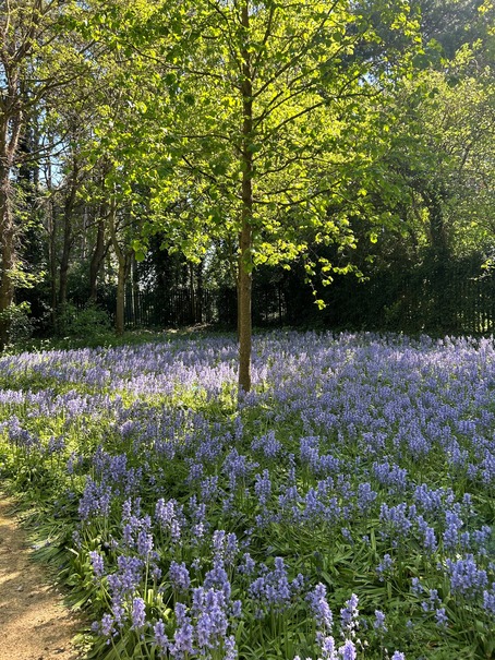
Northamptonshire sits in the middle of England and gets overlooked by walkers and cyclists heading for the Cotswolds or the Peak District. That is their loss. The county has over 3,000 miles of public rights of way, a river valley that runs its entire length, ancient woodlands carpeted with bluebells in spring, disused railways turned into traffic-free cycling paths, and canal towpaths that connect villages without touching a road. The terrain is gentle but not flat, with enough rolling farmland and wooded ridges to make a walk feel like an outing rather than a trudge.
This guide covers long-distance trails, circular walks, traffic-free cycling routes, canal towpaths, nature reserve trails and mountain biking spots across the county. We have included distances, surfaces, parking information and practical notes for each entry. Routes are organised by area to help you plan a day out or a longer exploration.
All details were accurate at time of research in March 2026. Routes, parking charges and facilities can change, so we recommend checking with the relevant authority or landowner before setting out.
Northampton and the Southern County
The area around the county town offers a surprising density of walking and cycling routes, from traffic-free railway paths and ancient woodland to canal towpaths and reservoir circuits. Several routes start within minutes of the town centre.
Brampton Valley Way
Walking and cycling route
A 14-mile traffic-free path running between Northampton and Market Harborough along a disused railway line, forming part of National Cycle Network Route 6
The surface is compacted stone and earth, suitable for hybrid and mountain bikes, pushchairs and wheelchairs on drier days
Two former railway tunnels on the route at Kelmarsh (480 metres) and Oxendon (422 metres) add atmosphere and a sense of adventure
The route is virtually flat throughout, following the old railway gradient with no significant climbs
Free car parking at Boughton Crossing, Brampton Halt, Spratton, Draughton Crossing and Kelmarsh Station
Brixworth Country Park sits just off the route and provides a café, toilets, cycle hire and additional parking
The full route takes approximately 5 to 6 hours to walk or 2 to 3 hours to cycle at a moderate pace
Off-road or hybrid bicycles are recommended; road bikes are not suitable for the surface
The Brampton Valley Way is the most popular traffic-free route in the county, and for good reason. Fourteen miles of flat, car-free path through open countryside, with two railway tunnels that children find thrilling and adults find atmospheric. The old railway gradient means there are no hills worth mentioning, which makes it accessible to families and leisure cyclists who want distance without difficulty. Brixworth Country Park provides a natural stopping point roughly a third of the way from the Northampton end, and the car parks at intervals along the route mean you can walk or ride as much or as little as you choose. It connects at Market Harborough with the town centre, pubs and cafés.
Address: Boughton Crossing car park, Brampton Lane, Chapel Brampton, Northampton NN6 8AB (southern end)
Website:https://www.westnorthants.gov.uk/major-parks/brampton-valley-way
How to book: Open access; free admission and free parking
Pitsford Water Circuit
Walking and cycling route
A 7.5-mile hard-surfaced circuit around Pitsford Reservoir, eight miles north of Northampton
The surface is compacted gravel throughout, suitable for pushchairs, wheelchairs, hybrid bikes and mountain bikes
The reservoir covers 413 hectares and is a designated nature reserve managed by Anglian Water
Look out for great crested grebes, goldeneye, little egrets, northern shovelers and other waterbirds throughout the year
Allow 2 to 4 hours for walking or 1 to 2 hours for cycling, depending on pace and stops
Cycle hire available at the Brixworth Country Park visitor centre, including bikes suitable for children
Brixworth Country Park café at the northern end serves hot and cold food, drinks and ice cream
Car park charges apply at Brixworth Country Park; the reservoir circuit is free to access
The Pitsford Water circuit is the most popular walk in the county according to user reviews, and the hard surface means it works in any season without turning into a mud bath. The reservoir is large enough that the circuit feels like a proper outing, and the birdlife on the water provides a constantly shifting foreground. Walkers share the path with cyclists, so stay alert on blind corners, but the path is wide enough for comfortable coexistence. The café at Brixworth Country Park makes a natural start and finish point, and the cycle hire means you can ride if your legs are feeling ambitious.
Address: Brixworth Country Park, Northampton Road, Brixworth NN6 9DG
Website:https://www.westnorthants.gov.uk/brixworth-country-park
How to book: No booking needed; car park pay on arrival
Harlestone Firs and Dallington Heath
Walking route
A 300-acre area of mixed woodland and heathland just northwest of Northampton, within easy reach of the town centre
Circular walks of 3 to 6 miles through pine woodland, broadleaf forest and open heath
The Harlestone Firs and Dallington Heath loop covers approximately 6 kilometres with minimal elevation gain
Seasonal highlights include bluebells and primroses in spring, with deer and foxes present year-round
The heathland was once common land used for grazing and retains a distinctive open character among the surrounding woodland
Car parking available near Harlestone Heath Garden Centre on Harlestone Road
Paths vary from well-surfaced tracks to softer woodland trails; boots recommended in winter
Dogs welcome; popular with local dog walkers
Harlestone Firs is the nearest proper woodland walk to Northampton town centre, and the combination of pine forest, broadleaf woodland and open heath gives it more variety than you might expect from a single site. The trails are well networked, so you can adjust your route length on the go, and the lack of significant hills makes it suitable for families with younger walkers. In spring, the bluebells are excellent, and on a winter morning the pine trees give the place a stillness that feels a long way from the nearby town. Boots are worth wearing from November through March.
Address: Harlestone Road, near Northampton (park near Harlestone Heath Garden Centre)
Website: Check West Northamptonshire Council countryside pages
How to book: Open access; no booking needed
Salcey Forest Trails
Walking and cycling route
Ancient woodland managed by Forestry England, located between Northampton and Milton Keynes
A 4.4-mile family cycling trail starts from the car park behind the café, on a wide, smooth, largely flat surface
Walking trails range from the 1-mile Elephant Trail for young families to the 5-mile forest circuit for longer outings
The Elephant Trail features carved wooden animals hidden along the route and a Gruffalo sculpture
Cycle hire available on site, including tag-alongs, electric bikes and adaptive bikes
The cycling trail crosses public roads in two places and shares some sections with walkers and horse riders
Car park charges apply (check Forestry England website); café on site serving food and drinks
Open every day except Christmas Day; summer hours 8am to 9pm, winter hours 8am to 7pm
Salcey Forest works as both a walking and cycling destination, with trails that range from a gentle family cycle on smooth paths to longer walks through ancient woodland where some of the oaks predate the English Civil War. The family cycling trail is deliberately designed for building confidence: wide, flat and largely smooth, with enough turns and shade to keep it interesting. The Elephant Trail is a reliably engaging walking route for young children, with carved animals to spot along the way. Bring a picnic in summer and find a clearing among the trees.
Address: Wootton Road, Hartwell, Northampton NN7 2HX
Website:https://www.forestryengland.uk/salcey-forest
How to book: No booking needed; car park pay on arrival
Northampton Bike Park
Cycling route
A 40-acre mountain bike park built on a former golf course, with trails graded from green to black for all abilities
Free to ride; car parking charges apply via the PopPay Plus app
Green-graded flow trails for families and beginners, with blue, red and black options for experienced riders
Machine-built trails with berms, rollers and jumps designed for mountain bikes
Suitable for balance bikes and young children on the green trails through to advanced riders on the black runs
Located within Northampton, making it one of the most accessible mountain bike parks in the Midlands
Open year-round; trails can be muddy after rain
No bike hire on site; bring your own equipment
Northampton Bike Park is a purpose-built mountain biking facility that opened in 2022 on a former golf course, and the fact that it is free to ride makes it unusual in the region. The green trails are genuine beginner-level flow trails where families can ride together, and the progression through blue, red and black grades means experienced riders have something to aim for too. The park is within the town boundary, which makes it remarkably accessible for what amounts to a proper mountain bike venue. Bring your own bike and helmet.
Address: Northampton Bike Park, Northampton (check website for exact directions)
Website:https://northamptonbikepark.org/
How to book: Open access; free to ride, parking charges apply
Grand Union Canal: Stoke Bruerne to Blisworth
Walking route
A flat towpath walk along the Grand Union Canal from the historic canal village of Stoke Bruerne to Blisworth and beyond
The main loop from Stoke Bruerne to Blisworth Tunnel and back via Shutlanger covers approximately 4 miles and takes 1 hour 45 minutes
The southern portal of Blisworth Tunnel (2,813 metres, the third longest navigable canal tunnel in England) is a dramatic feature on the route
Watch narrowboats navigate the flight of seven locks through Stoke Bruerne village
The Canal and River Trust Museum at Stoke Bruerne tells the story of Britain’s inland waterways
The Boat Inn at Stoke Bruerne serves food and drink canalside
Flat throughout; suitable for pushchairs on the towpath sections
Free to walk; museum has a small admission charge
The canal walk from Stoke Bruerne to Blisworth Tunnel is one of the most atmospheric short walks in the county. The towpath is flat and easy, the lock gates at Stoke Bruerne provide free entertainment as narrowboats rise and fall through them, and the southern portal of Blisworth Tunnel is imposing enough to make you pause. The extended circular via Shutlanger adds countryside and a stretch of quiet lane. Time it for a summer afternoon and finish with a drink at The Boat Inn, watching the boats come through.
Address: Stoke Bruerne, Towcester NN12 7SE
Website: Check Canal and River Trust website
How to book: Open access; no booking needed
Castle Ashby Circular
Walking route
A 6.5-mile circular walk through the estate and surrounding villages of Castle Ashby, taking approximately 2.5 to 3 hours
The route passes Castle Ashby House (ancestral home of the Marquess of Northampton) and its 10,000-acre estate
Takes in the villages of Whiston and Chadstone, with views across rolling Northamptonshire farmland
A steep climb to Whiston Church rewards with views over the Nene Valley
Mix of field paths, estate tracks and quiet lanes; can be muddy after rain
The Falcon at Castle Ashby serves food and drink and makes a good start or finish point
Castle Ashby Gardens (35 acres) are separately ticketed if you wish to visit
Free to walk the public footpaths; no booking needed
The Castle Ashby circular is one of the classic Northamptonshire walks, combining a stately home backdrop, rolling farmland, a couple of photogenic villages and one proper climb that earns you a view. The route is well marked and mostly follows public footpaths across estate land, which means the scenery is maintained to a high standard without feeling manicured. Whiston Church, perched on its ridge, is the highlight for views, and The Falcon at Castle Ashby provides a civilised end to the outing. Boots are essential from October through April.
Address: Castle Ashby, Northampton NN7 1LQ (start from the village)
Website: Check northamptonshirewalks.co.uk for route maps
How to book: Open access; no booking needed
The Norbital (NCN Route 539)
Cycling route
An 18-mile circular cycle route around the edges of Northampton, connecting residential areas with employment and education sites
Part of the National Cycle Network, combining dedicated cycle paths, quiet roads and shared-use paths
Connects Brackmills industrial estate, Moulton Park, the University of Northampton and residential areas
A practical commuting route as well as a leisure ride
Mostly on paved surfaces, suitable for road bikes and hybrids
The full circuit takes approximately 2 hours at a moderate cycling pace
Free to use; no dedicated parking, but multiple access points throughout Northampton
Signposted as NCN Route 539
The Norbital is not the most scenic route in Northamptonshire, but it serves a purpose that few other routes do: a complete circuit of Northampton on largely traffic-free or quiet-road cycling paths. It works as a commuting route, a training ride, or a way to see the outer edges of the town from a different perspective. The signed route means navigation is straightforward, and the mix of path types keeps it varied enough to hold your attention.
Address: Various access points around Northampton
Website: Check Sustrans National Cycle Network for route details
How to book: Open access
The Nene Valley and East Northamptonshire
The River Nene runs the length of Northamptonshire from west to east, and its valley provides the county’s richest concentration of walking and cycling routes. Nature reserves, country parks and the Nene Way long-distance trail make this area the natural heart of outdoor Northamptonshire.
The Nene Way
Walking route
A waymarked long-distance footpath of 110 miles following the River Nene from Badby in west Northamptonshire to Sutton Bridge in Lincolnshire
The Northamptonshire section covers approximately 70 miles, passing through Northampton, Wellingborough, Thrapston, Oundle and Fotheringhay
The route passes through some of the most important wetland habitats in England, including Summer Leys, Titchmarsh and Stanwick Lakes nature reserves
Can be walked in sections of any length; popular day-walk sections include Badby to Northampton, Wellingborough to Thrapston, and Barnwell to Wansford
Terrain is predominantly flat river valley, with gentle rises through farmland between riverside sections
Connects with the Knightley Way at Badby and the Lyveden Way at Wadenhoe
Well waymarked with the Nene Way symbol throughout
Public transport connections at Northampton, Wellingborough and Oundle make linear walks practical
The Nene Way is the backbone of walking in Northamptonshire. It follows the river from its source in the west of the county through to the fens of Lincolnshire, and the Northamptonshire sections are consistently good: riverside meadows, nature reserves rich with birdlife, historic villages like Fotheringhay and the handsome market town of Oundle. Walking it in sections lets you sample the best parts without committing to a week-long expedition. The stretch from Barnwell Country Park to Wansford, via Fotheringhay, is particularly scenic and historically resonant.
Address: Various start points; Badby village (western end), Northampton town centre, Wellingborough, Oundle
Website: Check LDWA (Long Distance Walkers Association) for route details
How to book: Open access; no booking needed
Stanwick Lakes Trails
Walking and cycling route
A 750-acre nature reserve and countryside attraction in the Nene Valley near Rushden, with 11 kilometres of cycle paths
A 4-mile linear cycling route runs from Irthlingborough towards Thrapston along a former railway line (NCN Route 71)
Walking trails include a 2.5-kilometre Main Lake Circuit and a 6-kilometre Three Lakes Walk
The Nene Way passes through the site, enabling longer linear walks along the river
Bike hire available from March to November for all ages
The adventure playground and water play area make it a combined family destination
Café on site; car parking charges apply
Paths are level and well surfaced, suitable for pushchairs and wheelchairs
Stanwick Lakes offers some of the best-maintained walking and cycling paths in the Nene Valley. The linear cycling route along the former railway towards Thrapston is flat, traffic-free and extends naturally into a longer ride via connecting bridleways. The walking trails around the lakes combine well-surfaced paths with views over wetlands that are home to kingfishers, herons and otters. The bike hire means you can arrive without equipment and still get out on two wheels.
Address: Stanwick, Wellingborough NN9 6GY
Website:https://stanwicklakes.org.uk/
How to book: No booking needed; bike hire first-come-first-served or via website
Summer Leys Nature Reserve
Walking route
A 2-mile circular walk around a former gravel pit turned wetland nature reserve, managed by the Wildlife Trust for Bedfordshire, Cambridgeshire and Northamptonshire
Located 3 miles from Wellingborough in the Nene Valley
Multiple bird hides along the route provide close views of the lakes and their resident and visiting birdlife
Species regularly seen include gadwall, tufted duck, shoveler, teal, wigeon, goldeneye, cormorant, little egret and great white egret
Paths are mainly flat and accessible, with some sections along an old railway line
Allow approximately 1 hour for the circuit, longer if stopping at the hides
Parking costs £4 for 4 hours or £6 for the full day; free for Wildlife Trust members (register vehicle in advance)
Wheelchair-accessible route available with kissing gates throughout
Summer Leys is a quiet, focused walk where the birdlife is the main attraction. The reserve was created from former gravel workings and has matured into one of the Nene Valley’s most productive wetland sites. The hides are well positioned and well maintained, and even a short visit is likely to produce sightings of species you would struggle to see elsewhere in the county. The circular route is short enough to fit into a morning and flat enough to suit all abilities.
Address: Wollaston Road, Great Doddington, Wellingborough NN29 7TJ
Website:https://www.wildlifebcn.org/summer-leys
How to book: Open access; parking charges apply
Titchmarsh Nature Reserve and Thrapston Lakes
Walking route
A 72.7-hectare nature reserve north of Thrapston, managed by the Wildlife Trust for Bedfordshire, Cambridgeshire and Northamptonshire
Circular walks of 5 to 8 miles combine the nature reserve with the Nene Way and Thrapston Lakes
Several large lakes attract heron, goosander, wigeon, gadwall, reed warbler and sedge warbler
The Nene Way passes through the reserve, connecting it to Stanwick Lakes to the south and Oundle to the north
Hard-surfaced track with kissing gates to one bird hide; other paths are grass and can be muddy
Free admission; small car parks at Thrapston gravel pits and Aldwinkle (off Lowick Lane)
Allow 2 to 3 hours for the full Thrapston and Titchmarsh circular
Best visited in spring for warblers or autumn and winter for overwintering wildfowl
The walk around Titchmarsh and Thrapston’s lakes follows the Nene through a landscape that was once gravel workings and has evolved into rich wetland habitat. The birding is consistently good, with the reed-fringed lakes attracting species that are uncommon elsewhere in the county. The circular route combines riverside walking, open lakeside paths and a stretch of old railway line, giving it more textural variety than the distance might suggest. Combine it with a stop in Thrapston or continue north along the Nene Way towards Oundle.
Address: Thrapston, Northamptonshire (car park off Huntingdon Road)
Website:https://www.wildlifebcn.org/titchmarsh
How to book: Open access; free admission
Fotheringhay and the Upper Nene
Walking route
Circular walks of 4 to 7 miles starting from the historic village of Fotheringhay, where Mary Queen of Scots was executed in 1587
The walks follow the River Nene through some of its most photogenic stretches in the county
Fotheringhay Church (the Collegiate Church of the Blessed Virgin Mary and All Saints) dominates the village skyline
The castle mound, where only earthworks remain, is freely accessible and provides views across the river meadows
Routes extend to Woodnewton, Elton or along the Nene Way towards Oundle
Mix of riverside paths, field paths and quiet lanes; can be muddy in the river meadows
The village has no pub currently open, so bring food and water or combine with a stop in Oundle (4 miles)
Free parking on the village road near the church
Fotheringhay is one of those places where history and landscape combine to create a walk that stays with you. The castle mound where Mary Queen of Scots was imprisoned and executed is now a grassy hump beside the river, and the church that rises above the village is one of the finest in the county. The walking routes radiate outward through river meadows and gentle farmland, and the stretch of the Nene here is wide, slow and beautiful. The lack of a village pub means you need to plan ahead, but the walk itself needs no improvement.
Address: Fotheringhay, near Oundle PE8 5HZ
Website: Check northamptonshirewalks.co.uk for route maps
How to book: Open access; no booking needed
East Northants Greenway
Walking and cycling route
A traffic-free walking and cycling route linking Rushden, Higham Ferrers and Irthlingborough along a former railway line
The route passes through the Irthlingborough Lakes and Meadows Nature Reserve with views across the Nene Valley
Level surface throughout, suitable for pushchairs, wheelchairs and all types of bicycle
Connects at the Irthlingborough end with the cycling routes at Stanwick Lakes
No significant hills; follows the old railway gradient
Free to use with multiple access points along the route
Passes close to Rushden Lakes shopping and leisure complex
A practical commuting and leisure route connecting three towns
The East Northants Greenway is a useful traffic-free link between three towns that also works as a leisure route. The section through Irthlingborough Lakes and Meadows is the scenic highlight, with views over wetland habitats that provide a surprising amount of natural interest for what is essentially an urban connector route. It links naturally with the cycling paths at Stanwick Lakes, giving you the option to extend a ride into the wider Nene Valley network.
Address: Crown Park, Rushden (southern end) to Irthlingborough
Website:https://www.northnorthants.gov.uk/walking-and-cycling/greenway
How to book: Open access; free to use
Irchester Country Park Trails
Walking route
83 hectares of mixed woodland in a former ironstone quarry near Wellingborough, with three named walking trails
The Woodpecker Trail, Woodland Trail and Ironstone Trail offer loops from short strolls to 2-mile circuits
The Ironstone Trail traces the quarrying history of the site, passing the Dragline Viewpoint and a Megalosaurus skeleton sculpture
The Nene Way passes through the park, connecting it to the wider walking network
The Irchester Narrow Gauge Railway museum preserves the quarry’s industrial heritage
The Quarryman’s Rest Café serves food, drinks and homemade cakes
Car parking: £5.20 for up to 8 hours
Wheelchair available to borrow from the Visitor Centre
Irchester Country Park is a quietly interesting walk that gains character from its industrial past. The ironstone quarrying that shaped the landscape has given way to mixed woodland, and the trails weave through trees that have reclaimed the former workings. The Ironstone Trail adds an educational element without being heavy-handed, and the café makes it a comfortable half-day outing. The Nene Way connection means you can extend a walk into the surrounding countryside.
Address: Gypsy Lane, Irchester, Wellingborough NN29 7DL
Website:https://www.northnorthants.gov.uk/irchester-country-park
How to book: No booking needed; car park pay on arrival
Fermyn Woods and the Rockingham Forest
Walking and cycling route
Over 100 acres of ancient woodland and meadows near Brigstock, between Thrapston and Corby
Three waymarked walking trails: the Skylark Nature Trail (all-abilities, surfaced paths), the Woodland Walk (1 mile), and the Fermyn Forest Walk (2+ miles on mixed surfaces)
Two bridleways through the forest are open to cyclists
Nationally famous for the purple emperor butterfly, which can be seen grounded here in July
Other wildlife includes red kites, bullfinches, hawfinches, nightingales, skylarks and green woodpeckers
Art installations and sculptures are distributed through the woodland
Café serving refreshments; car park charges apply
The ancient trees create a dense canopy that makes the forest atmospheric in any weather
Fermyn Woods sits within the remnants of the old Rockingham Forest, and the ancient trees give it a character that younger plantations cannot match. The walking trails cater to different abilities, from the surfaced Skylark trail to the longer forest walk on softer ground. In July, butterfly enthusiasts from across the country come here for the purple emperor, which is more reliably seen at ground level in Fermyn than almost anywhere else in England. The rest of the year, the combination of woodland birdsong, art installations and dappled light through the canopy is reason enough to visit.
Address: Brigstock Road, near Corby NN14 1EZ
Website: Check North Northamptonshire Council for details
How to book: No booking needed
West Northamptonshire, Daventry and the Canal Country
The western side of the county is defined by rolling countryside, canal networks and some of the best bluebell woodlands in the Midlands. The landscape here is quieter and less visited than the Nene Valley, with walks that often follow field paths between stone-built villages.
The Knightley Way
Walking route
A waymarked 12-mile walking route from Badby to Greens Norton, passing through countryside once owned by the Knightley family of Fawsley Hall
The route passes through Badby Woods (famous for bluebells in late April), Fawsley Park with its Capability Brown landscape, and the villages of Foxley and Farthingstone
Fawsley Hall, a 15th-century hall now operating as a hotel, and its lakes and parkland form a centrepiece of the walk
Connects with the Nene Way at Badby and the Grafton Way at Greens Norton, enabling longer through-walks
Terrain is undulating farmland and woodland; boots essential
Allow 5 to 6 hours for the full route, or walk shorter sections
No dedicated car parks on the route; roadside parking in Badby or Greens Norton
Waymarked and shown on Ordnance Survey maps
The Knightley Way is one of the finest walking routes in west Northamptonshire, threading through countryside that the Knightley family shaped over centuries. Badby Woods at the start of the walk are spectacular in late April when the bluebells carpet the woodland floor, and Fawsley Park provides a set-piece landscape that Capability Brown himself designed. The route is well waymarked but crosses farmland that can be muddy, so boots are non-negotiable. Walking the full 12 miles in a day is achievable, or you can cherry-pick the best sections.
Address: Start at Badby village, near Daventry NN11 3AR
Website: Check LDWA for route details
How to book: Open access; no booking needed
Badby Woods
Walking route
120 acres of ancient woodland owned by the Fawsley Estate and open to the public, adjacent to Badby village near Daventry
One of Northamptonshire’s finest bluebell woods, with carpets of blue typically peaking in late April to early May
Circular walks of 2 to 4 miles through mixed woodland with well-defined paths
The village of Badby hosts bluebell cream teas on the first Sunday of May each year
Connects to the Knightley Way and to Fawsley Park via footpaths
Small car park at the edge of the wood; roadside parking also available in Badby village
Paths can be steep in places and muddy year-round; boots essential
Dogs welcome on leads during bluebell season
Badby Woods in late April is one of the natural highlights of the Northamptonshire year. The bluebells grow in a density that photographs rarely do justice to, and the ancient woodland setting, with its mix of oak, ash and hazel, provides the kind of walking that makes you forget you are in the middle of England. The walks are short enough for families but atmospheric enough for anyone who appreciates woodland. Visit on a weekday if you can, as the bluebell weekends draw crowds.
Address: Badby, near Daventry NN11 3AR
Website:https://www.woodlandtrust.org.uk/visiting-woods/woods/badby-wood/ (Woodland Trust)
How to book: Open access; no booking needed
Everdon Stubbs
Walking route
A 73-acre ancient woodland and Site of Special Scientific Interest near Everdon, managed by the Woodland Trust
Mix of English oak, sessile oak, birch, sweet chestnut and sycamore
One of the few Northamptonshire woods where wild daffodils grow alongside bluebells in spring
A sensory trail with 12 posts invites visitors to identify trees by their leaves, bark, fruits and seeds
The Everdon Stubbs and Little Everdon loop covers approximately 9 kilometres (5.6 miles)
Shorter walks of 1 to 2 miles are possible within the wood itself
Small car park off the main road before the crossroads to The Stowes when travelling from Everdon
Dogs welcome; paths vary from firm tracks to softer woodland floor
Everdon Stubbs is a quiet woodland walk that rewards attention. The wild daffodils in spring are a genuinely rare sight in this part of England, and the sensory trail adds an educational dimension without being patronising. The wood is large enough that you can walk for an hour without retracing your steps, and the mix of tree species creates a canopy that changes character from one section to the next. It pairs well with a visit to Badby Woods or a walk along the Knightley Way.
Address: Near Everdon, Daventry (car park off main road)
Website:https://www.woodlandtrust.org.uk/visiting-woods/woods/everdon-stubbs/
How to book: Open access; no booking needed
Daventry Country Park and Borough Hill
Walking route
Daventry Country Park covers 160 acres centred around a reservoir that feeds the Grand Union Canal
Three waymarked circular trails: the Reservoir Walk (2.5 miles), Meadow Walk (1.5 miles) and Woodland Walk (1 mile)
The Reservoir Walk is flat and fully surfaced, suitable for pushchairs and wheelchairs
Borough Hill, adjacent to the park, is an Iron Age hillfort offering sweeping views over the surrounding countryside
Green Flag Award-winning park with play area, café and picnic areas
Free entry to the park; car park charges apply
Dogs welcome throughout the park and on Borough Hill
Combine the reservoir walk with a climb to Borough Hill for a varied half-day outing
Daventry Country Park and Borough Hill make a natural pairing. The park itself is well maintained and family-friendly, with a reservoir walk that is accessible to everyone and a café that serves as a comfortable base. Borough Hill adds the element the park lacks: height, views and a sense of history. The Iron Age hillfort at the top is one of the largest in the Midlands, and on a clear day the views extend across the Northamptonshire countryside in every direction. Walk the reservoir first, then climb the hill for the reward.
Address: Northern Way, Daventry NN11 0SQ
Website:https://www.westnorthants.gov.uk/daventry-country-park
How to book: No booking needed; car park pay on arrival
Braunston Canal Walk
Walking route
A gentle canal walk exploring the junction of the Grand Union and Oxford canals at the village of Braunston
Loop walks of 2.5 to 6 miles along the canal towpaths, passing through locks, over bridges and past the entrance to Braunston Tunnel
Braunston is one of the most historically important canal junctions in England, where the Oxford Canal (completed 1790) meets the Grand Union
The flight of six Braunston Locks ascends 35.5 feet and provides constant activity during the boating season
Braunston Tunnel (1.2 miles) is visible from the towpath at its northern portal
The Old Plough and The Boatman pubs in the village serve food and drink
Flat towpath walking throughout; suitable for pushchairs
Free parking near the canal; no admission charge
Braunston sits at a junction that was once one of the busiest intersections in England’s canal network, and the walking here reflects that heritage. The towpaths in both directions are flat and easy, the locks provide a working spectacle during the boating season, and the village itself has enough character and pub options to make a proper stop. The tunnel entrance is an atmospheric turning point for a walk, and the combination of two canals means you can vary your route each time you visit.
Address: Braunston, near Daventry NN11 7HJ
Website: Check Canal and River Trust website
How to book: Open access; no booking needed
The Grafton Way
Walking route
A 13-mile waymarked footpath running southeast from Greens Norton to Cosgrove, connecting with the Knightley Way and the Grand Union Canal
The route passes through Towcester, crosses Watling Street (the ancient A5), and takes in the deserted village of Furtho
Undulating farmland with a mix of field paths, quiet lanes and stretches of canal towpath
Connects at Cosgrove with the Grand Union Canal, providing access to Milton Keynes via the towpath
The route takes approximately 5 to 6 hours to complete in full
Allow for muddy sections through farmland; boots essential
Waymarked and shown on Ordnance Survey maps
Can be combined with the Knightley Way for a two-day through-walk across the county
The Grafton Way is the quieter companion to the Knightley Way, running through the southern part of the county where the landscape rolls gently towards the Buckinghamshire border. The crossing of Watling Street, the old Roman road, adds a layer of historical depth, and the deserted village of Furtho provides an atmospheric waypoint. It is a proper day’s walk if done end to end, but the connection with the canal at Cosgrove means you can finish with a flat towpath section that eases tired legs.
Address: Start at Greens Norton, near Towcester NN12 8BS
Website: Check LDWA for route details
How to book: Open access; no booking needed
Fineshade Wood
Walking and cycling route
A Forestry England woodland near Corby with a 5-mile green-graded family cycling trail and 7 additional blue-graded mountain bike sections
Walking trails through the woodland, with connections to nearby Wakerley Woods
On-site bike hire including tag-alongs, electric bikes and adaptive bikes at the Grounds cycle centre
The Grounds café at Top Lodge serves meals, snacks and drinks with indoor and outdoor seating
Car parking is pay and display (approximately £4 all day)
The green cycling trail starts and finishes at the main car park, close to the visitor centre
The blue sections provide more technical riding for mountain bikers alongside the green route
Located on the edge of the old Rockingham Forest, with mature trees and varied woodland
Fineshade Wood is the best destination in Northamptonshire for a family cycling outing in a forest setting. The green trail is genuinely suitable for beginners and families, with a smooth surface and gentle gradients through mature woodland, while the blue sections offer enough challenge to keep more experienced riders engaged. The on-site bike hire removes the biggest barrier to a cycling day out, and the café at Top Lodge means you can make a morning or afternoon of it without needing to pack supplies.
Address: Top Lodge, Fineshade, near Corby NN17 3BB
Website:https://www.forestryengland.uk/fineshade-wood
How to book: No booking needed; bike hire first-come-first-served
The Northamptonshire Round
Walking route
A 54-mile circular walking route around Northampton, created by the Ten Foot Club walking group in 2003
The route starts and finishes at Brixworth Country Park and passes through Harlestone, Bugbrooke, Gayton, Piddington, Yardley Hastings and Sywell
Takes in Salcey Forest, sections of the Nene Valley, and rolling farmland between villages
Can be walked as a continuous multi-day route or broken into day-walk sections
Waymarked throughout and shown on Ordnance Survey maps
The route provides an overview of the diverse landscapes within a 15-mile radius of Northampton
Allow 3 to 4 days for the full circuit, or plan individual sections of 8 to 15 miles
Terrain is mixed: field paths, woodland tracks, quiet lanes and some road crossings
The Northamptonshire Round is the county’s own long-distance walking challenge, and it works because the route takes in a genuine cross-section of what Northamptonshire looks like. You walk through ancient forest, along river valleys, across farmland and through villages that range from tiny hamlets to substantial settlements. Breaking it into day sections is the practical approach for most walkers, and each section has enough character to stand on its own as a day out.
Address: Start at Brixworth Country Park, Northampton Road, Brixworth NN6 9DG
Website: Check northamptonshirewalks.co.uk for route details
How to book: Open access; no booking needed
Seasonal Highlights
Spring (March to May): Badby Woods and Everdon Stubbs are at their finest during the bluebell season, typically late April to early May. The Nene Way is at its most photogenic with river meadows coming into flower. Bird migration brings warblers to Titchmarsh and Summer Leys reserves.
Summer (June to August): Fermyn Woods’ purple emperor butterflies are on the wing in July. Canal towpaths at Stoke Bruerne and Braunston are busy with narrowboat traffic. The Brampton Valley Way and Salcey Forest cycling trails are at their best. Long evenings extend the walking day.
Autumn (September to November): The Northamptonshire Round and longer walks benefit from cooler temperatures and autumn colour in the woodlands. Birdwatching at Summer Leys and Titchmarsh improves as overwintering species arrive. Salcey Forest and Harlestone Firs are atmospheric with fallen leaves.
Winter (December to February): Pitsford Water circuit and the Nene Valley wetlands offer excellent winter birdwatching. Hard-surfaced routes like the Brampton Valley Way and Daventry Country Park reservoir remain usable when field paths are waterlogged. Borough Hill is bracing on a clear winter day.
A Note From Northants Life
Northamptonshire’s walking and cycling routes are quietly among the best in the Midlands, and the county’s low profile among outdoor enthusiasts means you can walk for miles without encountering crowds. The combination of river valleys, ancient woodland, canal networks and traffic-free railway paths provides variety that counties with more famous landscapes often lack.
If a route in this guide has changed, a new path has opened, or we have missed a walk or ride that deserves to be here, let us know through the Northants Life website. We will update the guide to keep it as useful as possible.
Before You Go
Boots are essential for field-path walks from October through April; the clay soil in Northamptonshire holds water and turns to heavy mud quickly
Cycle hire is available at Brixworth Country Park (Pitsford Water), Salcey Forest and Fineshade Wood; book ahead during school holidays
The Brampton Valley Way tunnels are unlit; a torch or phone light is recommended, especially with children
Ordnance Survey Explorer maps 207, 223 and 224 cover the majority of routes in this guide; the OS Maps app provides digital alternatives
Many country park car parks now use app-based payment (including PopPay Plus); check before you travel
The Nene Way, Knightley Way and Grafton Way are waymarked, but carrying a map is recommended as waymarks can be obscured by vegetation
Dogs are welcome on most routes but must be kept on leads near livestock; check individual nature reserve rules
Canal towpaths are shared with cyclists; walkers should stay aware and cyclists should ring a bell or call out when overtaking
Public transport connections to Northampton, Wellingborough and Oundle make linear walks practical without needing two cars